Trail Walking Orry-la-Ville - coye la fotet - Photo
 Rui Barbosa
Rui Barbosa

User GUIDE

© OpenStreetMap contributors
Length
Length
10.1 km
Max alt
Max alt
95 m
Uphill gradient
Uphill gradient
129 m
Km-Effort
Km-Effort  
11.8 km
Min alt
Min alt
35 m
Downhill gradient
Downhill gradient
129 m
Boucle
Boucle
Yes
Creation date :
2018-04-16 21:31:25.723
Updated on :
2022-07-11 04:37:38.761

(0 Reviews)

Walking
Walking
--
Difficulty : Easy

Scan this QR Code to open this trail in the SityTrail application

FREE GPS app for hiking

Logo SityTrail SityTrail

IGN / Geographical institutes

Download SityTrail from the App Store Download SityTrail from Google Play

Logo SityTrail SityTrail World

The world is yours!

Download SityTrail from the App Store Download SityTrail from Google Play Download SityTrail on Huawei AppGallery

About

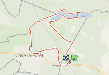
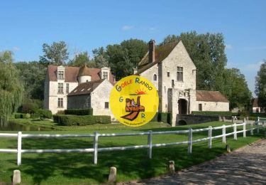
Trail Walking of 10.1 km to be discovered at Hauts-de-France, Oise, Orry-la-Ville. This trail is proposed by Rui Barbosa.

Description

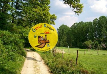
Balade Douce en forêt de Chantilly. Traversée de la petite et charmante ville de Coye-la-Foret, passage à travers des prés réservés aux chevaux.
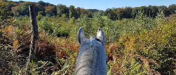
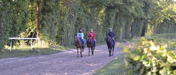
Traversée d'une petite partie d'entrainement au galop des chevaux de course, avant d'atteinte les étangs de Commelles, un des lieux les plus agréables en foret de Chantilly.

Elevation profile

Photos

Points of interest

Point of interest Coye-la-Forêt - Château de Coye - Photo
Rui Barbosa
COYE-LA-FORÊT 
Point of interest Lamorlaye - La foret de Coye - Photo
Rui Barbosa
LAMORLAYE 
Point of interest Lamorlaye - Entrainement des chevaux au galop - Photo
Rui Barbosa
Point of interest Coye-la-Forêt - Les étangs de Commelles - Photo
Rui Barbosa
COYE-LA-FORÊT 
Point of interest Coye-la-Forêt - Chateau de la reine blanche - Photo
Rui Barbosa

Positioning

Country:
France
Region :
Hauts-de-France
Department/Province :
Oise
Municipality :
Orry-la-Ville
Location:
Unknown
Start:(UTM)
462825 ; 5443058 (31U) N.

Trails nearby

Trail Walking Orry-la-Ville - Dans la forêt des moines - Orry-la-Ville - Photo
Walking
tracegps

Walking

Medium
(2)
Orry-la-Ville, Hauts-de-France, Oise, France
9.2 km | 11.2 km-effort
2h 30min
Yes
Trail Walking Coye-la-Forêt - SM_COYE la FORET_7.9Km - Photo
Walking
GR77LP

Walking

Medium
(3)
Coye-la-Forêt, Hauts-de-France, Oise, France
7.9 km | 10 km-effort
2h 40min
Yes
Trail Walking Orry-la-Ville - SM_MONTGRESIN_EST_8.2Km - Photo
Walking
GR77LP

Walking

Medium
(5)
Orry-la-Ville, Hauts-de-France, Oise, France
8.2 km | 9.2 km-effort
1h 51min
Yes
Trail Walking Pontarmé - MR_PONTARME-OUEST_4.9Km - Photo
Walking
GR77LP

Walking

Easy
(1)
Pontarmé, Hauts-de-France, Oise, France
4.9 km | 5.5 km-effort
1h 12min
Yes
Trail Walking Pontarmé - SM_PONTARME_EST(Chateau)_8.6Km - Photo
Walking

Walking

Medium
(5)
Pontarmé, Hauts-de-France, Oise, France
8.6 km | 9.7 km-effort
2h 9min
Yes
Trail Walking Luzarches - Autour d'Orry la Ville - Photo
Walking
tracegps

Walking

Medium
(1)
Luzarches, Ile-de-France, Val-d'Oise, France
22 km | 26 km-effort
4h 25min
Yes
Trail Walking Orry-la-Ville - La forêt des étangs de Comelle - Orry la Ville - Photo
Walking
tracegps

Walking

Medium
(1)
Orry-la-Ville, Hauts-de-France, Oise, France
11.4 km | 13 km-effort
4h 0min
Yes
Trail Walking Orry-la-Ville - FORET DE COYE BOUCLE 16 KM - Photo
Walking
gemau77

Walking

Very difficult
(1)
Orry-la-Ville, Hauts-de-France, Oise, France
16.2 km | 19.1 km-effort
5h 6min
No
Trail Walking Orry-la-Ville - Mongrésin Grand parcours - Photo
Walking
CC.RIDER

Walking

Easy
(1)
Orry-la-Ville, Hauts-de-France, Oise, France
21 km | 24 km-effort
5h 12min
Yes


Close
My subscriptions