


But de Neve But de l'Aiglette

collot
User
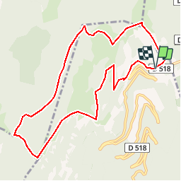

Length
10.4 km

Max alt
1641 m

Uphill gradient
609 m
Km-Effort
18.6 km

Min alt
1243 m

Downhill gradient
631 m
Boucle
Yes
Creation date :
2018-04-16 21:43:52.91
Updated on :
2018-04-16 21:43:52.91
--
Difficulty : Medium

FREE GPS app for hiking
 SityTrail
IGN / Geographical institutes
SityTrail Plus
The world is yours!
About
Trail Walking of 10.4 km to be discovered at Auvergne-Rhône-Alpes, Drôme, Chamaloc. This trail is proposed by collot.
Positioning
Country:
France
Region :
Auvergne-Rhône-Alpes
Department/Province :
Drôme
Municipality :
Chamaloc
Location:
Unknown
Start:(Dec)
Start:(UTM)
689494 ; 4967796 (31T) N.
Comments