Trail Walking Monceaux-sur-Dordogne - Monceaux/Dordogne les 2 puys - Photo

Monceaux/Dordogne les 2 puys

 grageot
grageot

User

© OpenStreetMap contributors
Length
Length
14.3 km
Max alt
Max alt
467 m
Uphill gradient
Uphill gradient
540 m
Km-Effort
Km-Effort  
22 km
Min alt
Min alt
180 m
Downhill gradient
Downhill gradient
543 m
Boucle
Boucle
Yes
Creation date :
2017-08-28 00:00:00.0
Updated on :
2017-08-28 00:00:00.0

(0 Reviews)

Walking
Walking
4h45
Difficulty : Medium

Scan this QR Code to open this trail in the SityTrail application

FREE GPS app for hiking

Logo SityTrail SityTrail

IGN / Geographical institutes

Download SityTrail from the App Store Download SityTrail from Google Play

Logo SityTrail SityTrail World

The world is yours!

Download SityTrail from the App Store Download SityTrail from Google Play Download SityTrail on Huawei AppGallery

About

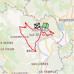
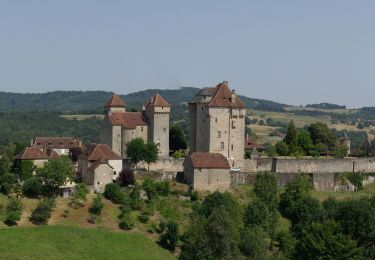
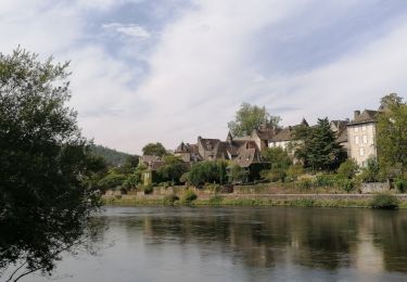
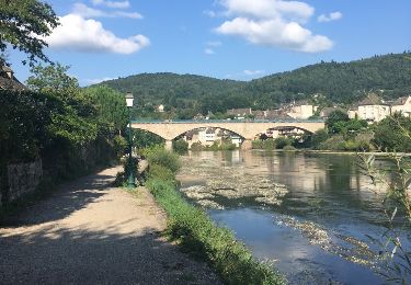
Trail Walking of 14.3 km to be discovered at New Aquitaine, Corrèze, Monceaux-sur-Dordogne. This trail is proposed by grageot.

Description

Une superbe randonnée proposée par le CD de la Corréze. Essentiellement sur chemins en sous-bois (idéal s'il fait chaud). Beaux panoramas sur la boucle de la Dordogne. Le gpx proposé par le site officiel n'est pas précis et plein d'erreurs.

Elevation profile

Positioning

Country:
France
Region :
New Aquitaine
Department/Province :
Corrèze
Municipality :
Monceaux-sur-Dordogne
Location:
Unknown
Start:(UTM)
414073 ; 4992620 (31T) N.

Trails nearby

Trail Motorbike Argentat-sur-Dordogne - Les tours de Merle - Beaulieu - Collonges - Photo
Motorbike
bernard_ostermann

Motorbike

Easy
Argentat-sur-Dordogne, New Aquitaine, Corrèze, France
162 km | 204 km-effort
4h 0min
No
Trail sport Monceaux-sur-Dordogne - Monceaux sur Dordogne - Photo
sport
hl44lv

sport

Very easy
Monceaux-sur-Dordogne, New Aquitaine, Corrèze, France
5.2 km | 8.2 km-effort
Unknown
Yes
Trail Bicycle tourism Bassignac-le-Bas - Beaulieu sur Dordogne-Argentat - Photo
Bicycle tourism
Gipebe

Bicycle tourism

Medium
Bassignac-le-Bas, New Aquitaine, Corrèze, France
32 km | 38 km-effort
2h 27min
No
Trail Walking Argentat-sur-Dordogne - argentât  - Photo
Walking
Django44380

Walking

Very easy
Argentat-sur-Dordogne, New Aquitaine, Corrèze, France
8.5 km | 10.3 km-effort
3h 57min
No
Trail Other activity Monceaux-sur-Dordogne - De Bros à Argentat  - Photo
Other activity
olk

Other activity

Medium
Monceaux-sur-Dordogne, New Aquitaine, Corrèze, France
8.7 km | 12.5 km-effort
2h 15min
No
Trail Walking Saint-Chamant - t42164281_l'ecole buissonniere - Photo
Walking
Gpoujade

Walking

Difficult
Saint-Chamant, New Aquitaine, Corrèze, France
10.3 km | 15.5 km-effort
3h 31min
Yes
Trail Mountain bike Argentat-sur-Dordogne - Wikiloc - Tour de la Xaintrie Noire (Corrèze) (2021) - Photo
Mountain bike
Gpoujade

Mountain bike

Very difficult
Argentat-sur-Dordogne, New Aquitaine, Corrèze, France
61 km | 83 km-effort
5h 44min
Yes
Trail Walking La Chapelle-Saint-Géraud - la chappelle Saint Geraud - Photo
Walking
martinjacque

Walking

Medium
(1)
La Chapelle-Saint-Géraud, New Aquitaine, Corrèze, France
5.7 km | 7.9 km-effort
1h 53min
Yes
Trail Walking Argentat-sur-Dordogne - Argentat - les crêtes - Photo
Walking
houbart

Walking

Medium
Argentat-sur-Dordogne, New Aquitaine, Corrèze, France
9.7 km | 13.2 km-effort
2h 54min
Yes


Close
My subscriptions