


Markstein

signorato
User
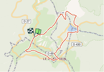

Length
8.2 km

Max alt
1263 m

Uphill gradient
390 m
Km-Effort
13.4 km

Min alt
935 m

Downhill gradient
390 m
Boucle
Yes
Creation date :
2018-04-16 22:11:24.543
Updated on :
2018-04-16 22:11:24.543
5m
Difficulty : Medium

FREE GPS app for hiking
 SityTrail
IGN / Geographical institutes
SityTrail Plus
The world is yours!
About
Trail Walking of 8.2 km to be discovered at Grand Est, Haut-Rhin, Oderen. This trail is proposed by signorato.
Description
trehkopf junfrauenkopf lac de la Lauch
Positioning
Country:
France
Region :
Grand Est
Department/Province :
Haut-Rhin
Municipality :
Oderen
Location:
Unknown
Start:(Dec)
Start:(UTM)
352087 ; 5310623 (32T) N.
Comments