Trail Walking Colombier-Saugnieu - Saugnieu 6 a 40 g0 d25 t24min - Photo

Saugnieu 6 a 40 g0 d25 t24min

© OpenStreetMap contributors
Length
Length
5.9 km
Max alt
Max alt
281 m
Uphill gradient
Uphill gradient
62 m
Km-Effort
Km-Effort  
6.7 km
Min alt
Min alt
245 m
Downhill gradient
Downhill gradient
62 m
Boucle
Boucle
Yes
Creation date :
2017-09-09 00:00:00.0
Updated on :
2017-09-09 00:00:00.0

(1 Reviews)

Walking
Walking
1h29
Difficulty : Easy

Scan this QR Code to open this trail in the SityTrail application

FREE GPS app for hiking

Logo SityTrail SityTrail

IGN / Geographical institutes

Download SityTrail from the App Store Download SityTrail from Google Play

Logo SityTrail SityTrail World

The world is yours!

Download SityTrail from the App Store Download SityTrail from Google Play Download SityTrail on Huawei AppGallery

About

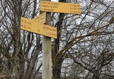
Trail Walking of 5.9 km to be discovered at Auvergne-Rhône-Alpes, Rhône, Colombier-Saugnieu. This trail is proposed by lydiaodile.

Description

Trajet voiture Saugnieu (20km, 27 minutes sans circulation)
Coordonnées GPS du départ du circuit : 45.729394,5.111206 ou 45]43'45"N, 5°06'40"
Adresse  2 chemin de Pillarday (=Pilardet) 38124 Colombier-Saugnieu
Rejoindre la Nationale 6(=D306), traverser St Bonnet de Mure, à la sortie de St Laurent de Mure, (après le 4e rond-point) serrer  à droite pour prendre la D154 puis, au 1er rond-point, 1e sortie vers D29 direction Colombier-Saugnieu. Au 1er rond-point sur la D29, prendre la 3e sortie, puis au rond-point suivant, la 1e sortie sur la route de Lyon.
Tourner dans la 3e  rue à gauche : au rond-point de la Mairie, prendre la 2e sortie (route du stade= D155) au 2e carrefour, prendre à droite la Rue du Gautier et (1e à droite) le Chemin de la Vendelière  puis 1e à droite Rue de la Rivoire. Puis 1e à gauche Chemin de Pillarday : Parking en bord de route, en face de l’entreprise

Elevation profile

Positioning

Country:
France
Region :
Auvergne-Rhône-Alpes
Department/Province :
Rhône
Municipality :
Colombier-Saugnieu
Location:
Unknown
Start:(UTM)
664270 ; 5066150 (31T) N.

Comments

Please log in to post a review or rate the element


Trails nearby

Trail Walking Satolas-et-Bonce - chauffard  - Photo
Walking
cricri34

Walking

Easy
Satolas-et-Bonce, Auvergne-Rhône-Alpes, Isère, France
3.9 km | 4.3 km-effort
57min
No
Trail Plane Colombier-Saugnieu - Barcelone - Photo
Plane
momogoofy

Plane

Very easy
Colombier-Saugnieu, Auvergne-Rhône-Alpes, Rhône, France
640 km | 821 km-effort
1h 5min
No
Trail Walking Satolas-et-Bonce - Haut de Bonce 7.5 a  41 g0.5 d16- pk imp des Mûres - Photo
Walking
jtraverse

Walking

Very easy
Satolas-et-Bonce, Auvergne-Rhône-Alpes, Isère, France
7.5 km | 8.1 km-effort
2h 34min
Yes
Trail Walking Charvieu-Chavagneux - Chavanos  - Photo
Walking
pzvictor

Walking

Charvieu-Chavagneux, Auvergne-Rhône-Alpes, Isère, France
9.2 km | 10.3 km-effort
2h 37min
Yes
Trail Walking Chamagnieu - parmilieu - Photo
Walking
cricri34

Walking

Very easy
Chamagnieu, Auvergne-Rhône-Alpes, Isère, France
44 km | 51 km-effort
2h 40min
No
Trail Walking Charvieu-Chavagneux - Chavanoz  marche 8.3 a73 - Photo
Walking
lydiaodile

Walking

Easy
Charvieu-Chavagneux, Auvergne-Rhône-Alpes, Isère, France
8.3 km | 9.3 km-effort
2h 45min
Yes
Trail Other activity Satolas-et-Bonce - Sato course a pied 11km - Photo
Other activity
franckben

Other activity

Very easy
Satolas-et-Bonce, Auvergne-Rhône-Alpes, Isère, France
10.9 km | 12.1 km-effort
1h 6min
Yes
Trail Motor Charvieu-Chavagneux - 31.08.13 - Photo
Motor
nuno1974

Motor

Very easy
Charvieu-Chavagneux, Auvergne-Rhône-Alpes, Isère, France
86 km | 115 km-effort
4h 17min
No
Trail Motor Charvieu-Chavagneux - weekend - Photo
Motor
nuno1974

Motor

Very easy
Charvieu-Chavagneux, Auvergne-Rhône-Alpes, Isère, France
39 km | 47 km-effort
2h 0min
No


Close
My subscriptions