


st quentin

bert16
User

Length
14.6 km

Max alt
157 m

Uphill gradient
263 m
Km-Effort
18.2 km

Min alt
45 m

Downhill gradient
292 m
Boucle
No
Creation date :
2018-04-16 22:36:28.136
Updated on :
2018-04-16 22:36:28.136
3h10
Difficulty : Easy

FREE GPS app for hiking
 SityTrail
IGN / Geographical institutes
SityTrail Plus
The world is yours!
About
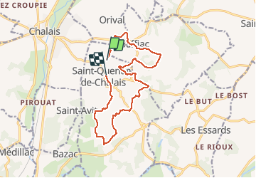
Trail Walking of 14.6 km to be discovered at New Aquitaine, Charente, Saint-Quentin-de-Chalais. This trail is proposed by bert16.
Positioning
Country:
France
Region :
New Aquitaine
Department/Province :
Charente
Municipality :
Saint-Quentin-de-Chalais
Location:
Unknown
Start:(Dec)
Start:(UTM)
270070 ; 5016385 (31T) N.
Comments