


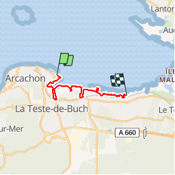
Pointe de l'Aiguillon - Port de Larros

611686735
User

Length
14.9 km

Max alt
7 m

Uphill gradient
61 m
Km-Effort
15.7 km

Min alt
-3 m

Downhill gradient
63 m
Boucle
No
Creation date :
2019-02-14 12:50:06.521
Updated on :
2019-04-14 23:09:30.537
3h33
Difficulty : Very easy

FREE GPS app for hiking
 SityTrail
IGN / Geographical institutes
SityTrail Plus
The world is yours!
About
Trail Walking of 14.9 km to be discovered at New Aquitaine, Gironde, Arcachon. This trail is proposed by 611686735.
Positioning
Country:
France
Region :
New Aquitaine
Department/Province :
Gironde
Municipality :
Arcachon
Location:
Unknown
Start:(Dec)
Start:(UTM)
647239 ; 4946416 (30T) N.
Comments