


Val d ayas Bussolas

chris13370
User
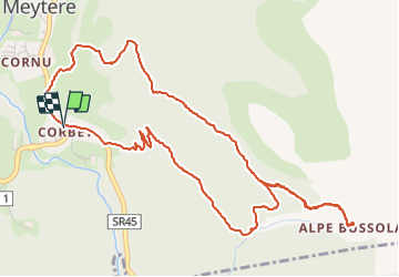

Length
6.7 km

Max alt
2179 m

Uphill gradient
676 m
Km-Effort
15.7 km

Min alt
1496 m

Downhill gradient
677 m
Boucle
Yes
Creation date :
2018-04-16 23:06:29.53
Updated on :
2018-04-16 23:06:29.53
3h33
Difficulty : Unknown

FREE GPS app for hiking
 SityTrail
IGN / Geographical institutes
SityTrail Plus
The world is yours!
About
Trail Walking of 6.7 km to be discovered at Aosta Valley, Unknown, Ayas. This trail is proposed by chris13370.
Description
mise en Jambe AM
Positioning
Country:
Italy
Region :
Aosta Valley
Department/Province :
Unknown
Municipality :
Ayas
Location:
Unknown
Start:(Dec)
Start:(UTM)
398528 ; 5072492 (32T) N.
Comments