


Val d ayas col Tournalin

chris13370
User
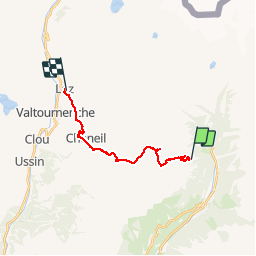

Length
14.4 km

Max alt
2778 m

Uphill gradient
808 m
Km-Effort
26 km

Min alt
1661 m

Downhill gradient
1192 m
Boucle
No
Creation date :
2018-04-16 23:06:29.781
Updated on :
2018-04-16 23:06:29.781
6h11
Difficulty : Difficult

FREE GPS app for hiking
 SityTrail
IGN / Geographical institutes
SityTrail Plus
The world is yours!
About
Trail Walking of 14.4 km to be discovered at Aosta Valley, Unknown, Ayas. This trail is proposed by chris13370.
Description
départ st Jacques 1200m descente par col nanar sur Val tournante le mardi 12/09/18
Positioning
Country:
Italy
Region :
Aosta Valley
Department/Province :
Unknown
Municipality :
Ayas
Location:
Unknown
Start:(Dec)
Start:(UTM)
400339 ; 5078642 (32T) N.
Comments