


-- de port vendres a collioure.gpx

georgein
User
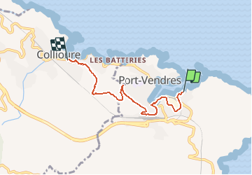

Length
5.1 km

Max alt
148 m

Uphill gradient
161 m
Km-Effort
7.2 km

Min alt
0 m

Downhill gradient
158 m
Boucle
No
Creation date :
2019-08-04 09:21:25.278
Updated on :
2020-01-31 20:31:22.225
--
Difficulty : Unknown

FREE GPS app for hiking
 SityTrail
IGN / Geographical institutes
SityTrail Plus
The world is yours!
About
Trail Walking of 5.1 km to be discovered at Occitania, Pyrénées-Orientales, Port-Vendres. This trail is proposed by georgein.
Positioning
Country:
France
Region :
Occitania
Department/Province :
Pyrénées-Orientales
Municipality :
Port-Vendres
Location:
Unknown
Start:(Dec)
Start:(UTM)
509363 ; 4707314 (31T) N.
Comments