


-- le chemin des muletiers.gpx

georgein
User
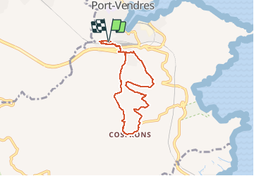

Length
8 km

Max alt
138 m

Uphill gradient
217 m
Km-Effort
10.9 km

Min alt
21 m

Downhill gradient
218 m
Boucle
Yes
Creation date :
2019-08-04 09:21:19.795
Updated on :
2020-01-31 20:31:15.531
--
Difficulty : Unknown

FREE GPS app for hiking
 SityTrail
IGN / Geographical institutes
SityTrail Plus
The world is yours!
About
Trail Walking of 8 km to be discovered at Occitania, Pyrénées-Orientales, Port-Vendres. This trail is proposed by georgein.
Positioning
Country:
France
Region :
Occitania
Department/Province :
Pyrénées-Orientales
Municipality :
Port-Vendres
Location:
Unknown
Start:(Dec)
Start:(UTM)
508411 ; 4706816 (31T) N.
Comments