


73V Geneuil (L'Archhz) La Sausse (Refuge des terres rouiges)

trietsch
User
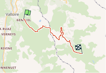

Length
11 km

Max alt
2495 m

Uphill gradient
1047 m
Km-Effort
24 km

Min alt
1724 m

Downhill gradient
632 m
Boucle
No
Creation date :
2017-09-24 00:00:00.0
Updated on :
2024-09-07 09:52:26.701
4h55
Difficulty : Difficult

FREE GPS app for hiking
 SityTrail
IGN / Geographical institutes
SityTrail Plus
The world is yours!
About
Trail Walking of 11 km to be discovered at Auvergne-Rhône-Alpes, Savoy, Valloire. This trail is proposed by trietsch.
Positioning
Country:
France
Region :
Auvergne-Rhône-Alpes
Department/Province :
Savoy
Municipality :
Valloire
Location:
Unknown
Start:(Dec)
Start:(UTM)
298985 ; 5004010 (32T) N.
Comments