


Compostelle 28 - Miramont -> Casteide

uru2010
User
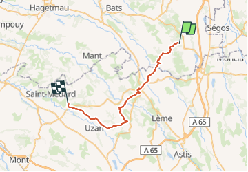

Length
36 km

Max alt
247 m

Uphill gradient
687 m
Km-Effort
46 km

Min alt
99 m

Downhill gradient
805 m
Boucle
No
Creation date :
2018-04-16 23:50:44.492
Updated on :
2018-04-16 23:50:44.492
9h38
Difficulty : Difficult

FREE GPS app for hiking
 SityTrail
IGN / Geographical institutes
SityTrail Plus
The world is yours!
About
Trail Walking of 36 km to be discovered at New Aquitaine, Landes, Miramont-Sensacq. This trail is proposed by uru2010.
Description
Chemin de Compostelle
Positioning
Country:
France
Region :
New Aquitaine
Department/Province :
Landes
Municipality :
Miramont-Sensacq
Location:
Unknown
Start:(Dec)
Start:(UTM)
715268 ; 4831166 (30T) N.
Comments