


ailles

hm
User
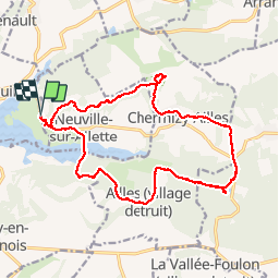

Length
17.4 km

Max alt
179 m

Uphill gradient
272 m
Km-Effort
21 km

Min alt
79 m

Downhill gradient
272 m
Boucle
Yes
Creation date :
2018-04-16 23:53:24.035
Updated on :
2018-04-16 23:53:24.035
3h44
Difficulty : Unknown

FREE GPS app for hiking
 SityTrail
IGN / Geographical institutes
SityTrail Plus
The world is yours!
About
Trail Walking of 17.4 km to be discovered at Hauts-de-France, Aisne, Chamouille. This trail is proposed by hm.
Description
30/09/17
Positioning
Country:
France
Region :
Hauts-de-France
Department/Province :
Aisne
Municipality :
Chamouille
Location:
Unknown
Start:(Dec)
Start:(UTM)
549483 ; 5479780 (31U) N.
Comments