


entre vignes et Charente

viam19
User
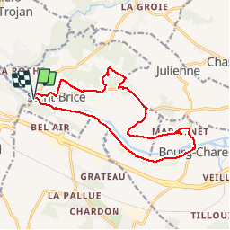

Length
16.1 km

Max alt
57 m

Uphill gradient
150 m
Km-Effort
18.1 km

Min alt
7 m

Downhill gradient
152 m
Boucle
Yes
Creation date :
2018-04-17 10:02:20.383
Updated on :
2018-04-17 10:02:20.383
4h47
Difficulty : Easy

FREE GPS app for hiking
 SityTrail
IGN / Geographical institutes
SityTrail Plus
The world is yours!
About
Trail Walking of 16.1 km to be discovered at New Aquitaine, Charente, Saint-Brice. This trail is proposed by viam19.
Photos


Positioning
Country:
France
Region :
New Aquitaine
Department/Province :
Charente
Municipality :
Saint-Brice
Location:
Unknown
Start:(Dec)
Start:(UTM)
711374 ; 5062949 (30T) N.
Comments