Trail Walking Villainville - Villainville / Cuverville: La tombe d'André Gide / Villainville - Photo

Villainville / Cuverville: La tombe d'André Gide / Villainville

© OpenStreetMap contributors
Length
Length
8.7 km
Max alt
Max alt
132 m
Uphill gradient
Uphill gradient
107 m
Km-Effort
Km-Effort  
10.2 km
Min alt
Min alt
99 m
Downhill gradient
Downhill gradient
108 m
Boucle
Boucle
Yes
Creation date :
2018-04-17 10:52:42.658
Updated on :
2021-01-16 15:48:15.894

(0 Reviews)

Walking
Walking
2h13
Difficulty : Easy

Scan this QR Code to open this trail in the SityTrail application

FREE GPS app for hiking

Logo SityTrail SityTrail

IGN / Geographical institutes

Download SityTrail from the App Store Download SityTrail from Google Play

Logo SityTrail SityTrail World

The world is yours!

Download SityTrail from the App Store Download SityTrail from Google Play Download SityTrail on Huawei AppGallery

About

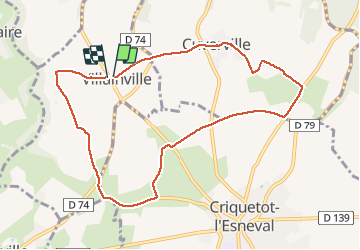
Trail Walking of 8.7 km to be discovered at Normandy, Seine-Maritime, Villainville. This trail is proposed by MarcherEnsemble.

Description

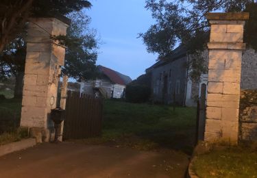
Départ du parking près de l'église de Villainville

Elevation profile

Photos

Points of interest

Point of interest Cuverville - Point 3 - Photo
MarcherEnsemble
CUVERVILLE 

Positioning

Country:
France
Region :
Normandy
Department/Province :
Seine-Maritime
Municipality :
Villainville
Location:
Unknown
Start:(UTM)
301082 ; 5504534 (31U) N.

Trails nearby

Trail Walking Étretat - étretat golf  - Photo
Walking
crocheval

Walking

Easy
(1)
Étretat, Normandy, Seine-Maritime, France
4.7 km | 6.7 km-effort
1h 42min
Yes
Trail Mountain bike Étretat - Etretat Yport - Photo
Mountain bike
tracegps

Mountain bike

Difficult
(4)
Étretat, Normandy, Seine-Maritime, France
35 km | 43 km-effort
3h 0min
Yes
Trail Walking Le Tilleul - La Valleuse d'Antifer  - Photo
Walking
GUIDE+

Walking

Difficult
(1)
Le Tilleul, Normandy, Seine-Maritime, France
12.5 km | 16.3 km-effort
3h 42min
Yes
Trail Walking La Poterie-Cap-d'Antifer - Etretat  - Photo
Walking
patrice76

Walking

Easy
(1)
La Poterie-Cap-d'Antifer, Normandy, Seine-Maritime, France
10.6 km | 14.4 km-effort
3h 8min
Yes
Trail Walking Étretat - Etretat les falaises - Photo
Walking
yvesportier

Walking

Easy
(1)
Étretat, Normandy, Seine-Maritime, France
7.6 km | 10.2 km-effort
2h 56min
Yes
Trail Walking Étretat - GR21 Etretat à Fécamp - Photo
Walking
bergo

Walking

Easy
(1)
Étretat, Normandy, Seine-Maritime, France
16.4 km | 21 km-effort
4h 42min
No
Trail Walking Étretat - Falaise d'Etretat - Photo
Walking
Axelloceane

Walking

Easy
Étretat, Normandy, Seine-Maritime, France
9 km | 11.8 km-effort
2h 19min
Yes
Trail Walking Villainville - Villainville - Photo
Walking
DDLEDANDY

Walking

Easy
(1)
Villainville, Normandy, Seine-Maritime, France
10.4 km | 12.7 km-effort
2h 46min
Yes
Trail Walking Étretat - Etretat (PVDB)  - Photo
Walking
GUIDE
Peter.vdbergh

Walking

Medium
Étretat, Normandy, Seine-Maritime, France
5.5 km | 7.2 km-effort
1h 38min
Yes


Close
My subscriptions