


09092017

AMOURETTE
User
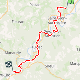

Length
27 km

Max alt
236 m

Uphill gradient
742 m
Km-Effort
37 km

Min alt
57 m

Downhill gradient
745 m
Boucle
No
Creation date :
2018-04-17 11:09:54.531
Updated on :
2018-04-17 11:09:54.531
8h29
Difficulty : Unknown

FREE GPS app for hiking
 SityTrail
IGN / Geographical institutes
SityTrail Plus
The world is yours!
About
Trail Walking of 27 km to be discovered at New Aquitaine, Dordogne, Thonac. This trail is proposed by AMOURETTE.
Positioning
Country:
France
Region :
New Aquitaine
Department/Province :
Dordogne
Municipality :
Thonac
Location:
Unknown
Start:(Dec)
Start:(UTM)
351169 ; 4987995 (31T) N.
Comments