


Aubazine

Gpoujade
User
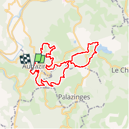

Length
19 km

Max alt
516 m

Uphill gradient
601 m
Km-Effort
27 km

Min alt
239 m

Downhill gradient
604 m
Boucle
Yes
Creation date :
2018-04-17 11:15:12.69
Updated on :
2018-04-17 11:15:12.69
3h35
Difficulty : Unknown

FREE GPS app for hiking
 SityTrail
IGN / Geographical institutes
SityTrail Plus
The world is yours!
About
Trail Walking of 19 km to be discovered at New Aquitaine, Corrèze, Aubazines. This trail is proposed by Gpoujade.
Description
Randonnée "du châtaignier à l'olivier " proposée par les Amis de Jayyoux" le 22.10.2017.
Positioning
Country:
France
Region :
New Aquitaine
Department/Province :
Corrèze
Municipality :
Aubazines
Location:
Unknown
Start:(Dec)
Start:(UTM)
395317 ; 5002967 (31T) N.
Comments