


Vitré circuit 1

olaze
User
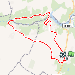

Length
9.4 km

Max alt
151 m

Uphill gradient
120 m
Km-Effort
11 km

Min alt
104 m

Downhill gradient
120 m
Boucle
Yes
Creation date :
2018-04-17 11:23:53.993
Updated on :
2018-04-17 11:23:53.993
2h26
Difficulty : Medium

FREE GPS app for hiking
 SityTrail
IGN / Geographical institutes
SityTrail Plus
The world is yours!
About
Trail Walking of 9.4 km to be discovered at New Aquitaine, Deux-Sèvres, Beaussais-Vitré. This trail is proposed by olaze.
Description
Départ Vitré.Bord du lac du Lambon . Châteauneuf. Côtes du Lambon
Positioning
Country:
France
Region :
New Aquitaine
Department/Province :
Deux-Sèvres
Municipality :
Beaussais-Vitré
Location:
Vitré
Start:(Dec)
Start:(UTM)
715903 ; 5129112 (30T) N.
Comments