


13-09-11 Sainte-Néomaye

olaze
User
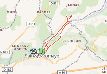

Length
7.7 km

Max alt
94 m

Uphill gradient
130 m
Km-Effort
9.5 km

Min alt
46 m

Downhill gradient
130 m
Boucle
Yes
Creation date :
2014-12-10 00:00:00.0
Updated on :
2014-12-10 00:00:00.0
--
Difficulty : Easy

FREE GPS app for hiking
 SityTrail
IGN / Geographical institutes
SityTrail Plus
The world is yours!
About
Trail Walking of 7.7 km to be discovered at New Aquitaine, Deux-Sèvres, Sainte-Néomaye. This trail is proposed by olaze.
Description
Randonnée bord de Sèvres .vallonné , sous bois , carrières.Club rando Bessines.
Photos


Positioning
Country:
France
Region :
New Aquitaine
Department/Province :
Deux-Sèvres
Municipality :
Sainte-Néomaye
Location:
Unknown
Start:(Dec)
Start:(UTM)
710598 ; 5139048 (30T) N.
Comments
Jolie balade