


Vitré circuit 2b

olaze
User

Length
9.8 km

Max alt
156 m

Uphill gradient
174 m
Km-Effort
12.1 km

Min alt
111 m

Downhill gradient
174 m
Boucle
Yes
Creation date :
2018-04-18 14:31:43.562
Updated on :
2018-04-18 14:31:43.562
2h37
Difficulty : Medium

FREE GPS app for hiking
 SityTrail
IGN / Geographical institutes
SityTrail Plus
The world is yours!
About
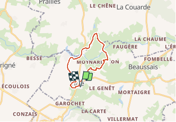
Trail Walking of 9.8 km to be discovered at New Aquitaine, Deux-Sèvres, Beaussais-Vitré. This trail is proposed by olaze.
Description
Départ MFR de Vitré .
Tour du village .
Vue sur l'étand du Lambon .
Château de La Bessière .
Petites vallées .
Sous bois .Novembre 2017.
Photos


Positioning
Country:
France
Region :
New Aquitaine
Department/Province :
Deux-Sèvres
Municipality :
Beaussais-Vitré
Location:
Vitré
Start:(Dec)
Start:(UTM)
715987 ; 5129077 (30T) N.
Comments