


montaner la Rouquère G2

LouisROGER
User GUIDE
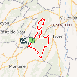

Length
11.9 km

Max alt
341 m

Uphill gradient
206 m
Km-Effort
14.6 km

Min alt
262 m

Downhill gradient
206 m
Boucle
Yes
Creation date :
2018-04-17 12:30:39.14
Updated on :
2018-04-17 12:30:39.14
3h10
Difficulty : Unknown

FREE GPS app for hiking
 SityTrail
IGN / Geographical institutes
SityTrail Plus
The world is yours!
About
Trail Walking of 11.9 km to be discovered at New Aquitaine, Pyrénées-Atlantiques, Montaner. This trail is proposed by LouisROGER.
Positioning
Country:
France
Region :
New Aquitaine
Department/Province :
Pyrénées-Atlantiques
Municipality :
Montaner
Location:
Unknown
Start:(Dec)
Start:(UTM)
257175 ; 4805335 (31T) N.
Comments