


Muespach le haut19km

ffdur
User
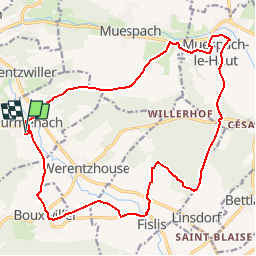

Length
19.8 km

Max alt
500 m

Uphill gradient
310 m
Km-Effort
24 km

Min alt
362 m

Downhill gradient
309 m
Boucle
Yes
Creation date :
2018-04-17 12:45:58.689
Updated on :
2018-04-17 12:45:58.689
5h01
Difficulty : Medium

FREE GPS app for hiking
 SityTrail
IGN / Geographical institutes
SityTrail Plus
The world is yours!
About
Trail Walking of 19.8 km to be discovered at Grand Est, Haut-Rhin, Durmenach. This trail is proposed by ffdur.
Positioning
Country:
France
Region :
Grand Est
Department/Province :
Haut-Rhin
Municipality :
Durmenach
Location:
Unknown
Start:(Dec)
Start:(UTM)
374903 ; 5264877 (32T) N.
Comments