


Beblenheim- Kientzheim - Beblenheiml

Schnacka
User
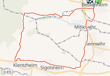

Length
11.6 km

Max alt
358 m

Uphill gradient
207 m
Km-Effort
14.3 km

Min alt
203 m

Downhill gradient
208 m
Boucle
Yes
Creation date :
2018-04-17 12:50:59.341
Updated on :
2018-04-17 12:50:59.341
3h06
Difficulty : Medium

FREE GPS app for hiking
 SityTrail
IGN / Geographical institutes
SityTrail Plus
The world is yours!
About
Trail Walking of 11.6 km to be discovered at Grand Est, Haut-Rhin, Beblenheim. This trail is proposed by Schnacka.
Description
Beau circuit à travers le vignoble sous-vosgien et de magnifiques vues sur la plaine d'Alsace, Colmar et la vallée de Kaysersberg
Photos


Positioning
Country:
France
Region :
Grand Est
Department/Province :
Haut-Rhin
Municipality :
Beblenheim
Location:
Unknown
Start:(Dec)
Start:(UTM)
375469 ; 5335167 (32U) N.
Comments