Trail Walking Delincourt - Delincourt Reilly Marais et bois  - Photo

Delincourt Reilly Marais et bois

© OpenStreetMap contributors
Length
Length
8.6 km
Max alt
Max alt
148 m
Uphill gradient
Uphill gradient
127 m
Km-Effort
Km-Effort  
10.3 km
Min alt
Min alt
74 m
Downhill gradient
Downhill gradient
127 m
Boucle
Boucle
Yes
Creation date :
2018-04-17 13:20:19.048
Updated on :
2018-04-17 13:20:19.048

(0 Reviews)

Walking
Walking
2h16
Difficulty : Medium

Scan this QR Code to open this trail in the SityTrail application

FREE GPS app for hiking

Logo SityTrail SityTrail

IGN / Geographical institutes

Download SityTrail from the App Store Download SityTrail from Google Play

Logo SityTrail SityTrail World

The world is yours!

Download SityTrail from the App Store Download SityTrail from Google Play Download SityTrail on Huawei AppGallery

About

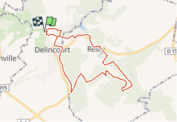
Trail Walking of 8.6 km to be discovered at Hauts-de-France, Oise, Delincourt. This trail is proposed by Marie-Claire-mcp.

Description

Départ Mairie, puis sente à côté de l'Eglise et chemin jusqu'à la route de Reilly. Puis Le marais et bois du gros Terrier route deReilly à Delincourt puis traverséedu bois du poteau jusqu'au cimetière de Delincourt et sentier qui descend vers le Mesnil et à gauche vers parking Mairie de Delincourt.

Elevation profile

Positioning

Country:
France
Region :
Hauts-de-France
Department/Province :
Oise
Municipality :
Delincourt
Location:
Unknown
Start:(UTM)
414827 ; 5455554 (31U) N.

Trails nearby

Trail Walking Delincourt - Delincourt, Le Mesnil, Reilly, La vierge, Delincourt - Photo
Walking
Marie-Claire-mcp

Walking

Medium
(1)
Delincourt, Hauts-de-France, Oise, France
8.7 km | 10.4 km-effort
2h 16min
Yes
Trail Walking Chambors - CHAMBORS - Lattainville-Delincourt-Reillly - Photo
Walking
marcel.F

Walking

Very easy
(1)
Chambors, Hauts-de-France, Oise, France
12.3 km | 15.2 km-effort
2h 54min
Yes
Trail Nordic walking Chambors - Marche Nordique 61 Chambors - Photo
Nordic walking
marcel.F

Nordic walking

Easy
(1)
Chambors, Hauts-de-France, Oise, France
8.4 km | 10.3 km-effort
1h 30min
Yes
Trail Walking Trie-Château - Trie Château - La vallée de l'Aunette - Photo
Walking
marcel.F

Walking

Difficult
(1)
Trie-Château, Hauts-de-France, Oise, France
11.8 km | 13.7 km-effort
3h 0min
Yes
Trail Walking Montjavoult - Montjavoult - Vaudancourt - Photo
Walking
marcel.F

Walking

Easy
(1)
Montjavoult, Hauts-de-France, Oise, France
10.2 km | 12.2 km-effort
2h 39min
Yes
Trail Walking Chambors - Chambors - le dolmen 12 - Photo
Walking
marcel.F

Walking

Easy
(1)
Chambors, Hauts-de-France, Oise, France
12.4 km | 16 km-effort
3h 31min
Yes
Trail Walking Chambors - Chambors - le dolmen 9 - Photo
Walking
marcel.F

Walking

Easy
(4)
Chambors, Hauts-de-France, Oise, France
9.3 km | 12.1 km-effort
2h 38min
Yes
Trail Walking Gisors - gisors champêtre et historique  - Photo
Walking
serge.guerroult

Walking

Difficult
Gisors, Normandy, Eure, France
12.1 km | 13.6 km-effort
2h 13min
Yes
Trail Walking Montjavoult - Montjavoult le gibet Valécourt - Photo
Walking
serge.guerroult

Walking

Difficult
Montjavoult, Hauts-de-France, Oise, France
12.8 km | 15.4 km-effort
2h 19min
Yes


Close
My subscriptions