![](/images/other/stat-length.png)
![Trail Walking Juvignac - juvignac les berges de la mosson - Photo](https://media.geolcdn.com/t/1900/400/ext.pjpeg?maxdim=2&url=https%3A%2F%2Fstatic1.geolcdn.com%2Fsiteimages%2Fupload%2Ffiles%2F1553511878bg_sport_marche.png)
juvignac les berges de la mosson
thecle
User
![Length](/images/other/stat-length.png)
Length
11 km
![Max alt](https://static1.geolcdn.com/siteimages/upload/files/1508320355ic_sort_altitude_max_24dp.png)
Max alt
138 m
![Uphill gradient](https://static1.geolcdn.com/siteimages/upload/files/1508320355ic_sort_den_pos_24dp.png)
Uphill gradient
156 m
![Km-Effort](/images/other/stat-length.png)
Km-Effort
13.1 km
![Min alt](https://static1.geolcdn.com/siteimages/upload/files/1508320355ic_sort_altitude_min_24dp.png)
Min alt
37 m
![Downhill gradient](https://static1.geolcdn.com/siteimages/upload/files/1508320355ic_sort_den_neg_24dp.png)
Downhill gradient
153 m
![Boucle](https://static1.geolcdn.com/siteimages/upload/files/16400158638029165_repeat_loop_refresh_sync_direction_icon.png)
Boucle
Yes
Creation date :
2018-04-17 13:37:30.014
Updated on :
2018-04-17 13:37:30.014
![Walking](https://static1.geolcdn.com/sitytour/trail-icons/101.png)
2h53
Difficulty : Easy
![Scan this QR Code to open this trail in the SityTrail application](https://capi.geolives.com/qq0zvz2zws4bq2lad0pu/sitytour/trails/868925/qr.png?size=200)
FREE GPS app for hiking
About
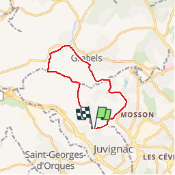
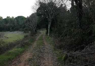
Trail Walking of 11 km to be discovered at Occitania, Hérault, Juvignac. This trail is proposed by thecle.
Description
départ du parc st hubert à juvignac , on rejoint les berges de la Mosson en passant derrière les Thermes. on passe par la source de l'Avy à Grabels puis on monte sur le plateau de Naussargues.
Positioning
Country:
France
Region :
Occitania
Department/Province :
Hérault
Municipality :
Juvignac
Location:
Unknown
Start:(Dec)
Start:(UTM)
564573 ; 4830131 (31T) N.
Comments
Trails nearby
![Trail Walking Grabels - Grabels (source de l'Avy, goule de Laval) - Photo](https://media.geolcdn.com/t/375/260/ext.jpg?maxdim=2&url=https%3A%2F%2Fstatic1.geolcdn.com%2Fsiteimages%2Fupload%2Ffiles%2F1553511878bg_sport_marche.png)
![Walking Walking](https://static1.geolcdn.com/sitytour/trail-icons/101.png)
Grabels (source de l'Avy, goule de Laval)
Walking
Easy
(1)
Grabels,
Occitania,
Hérault,
France
![](/images/other/stat-length.png)
10.7 km | 13.2 km-effort
2h 35min
![](https://static1.geolcdn.com/siteimages/upload/files/16400158638029165_repeat_loop_refresh_sync_direction_icon.png)
Yes
![Trail Walking Vailhauquès - belair grabels - Photo](https://media.geolcdn.com/t/375/260/ext.jpg?maxdim=2&url=https%3A%2F%2Fstatic1.geolcdn.com%2Fsiteimages%2Fupload%2Ffiles%2F1553511878bg_sport_marche.png)
![Walking Walking](https://static1.geolcdn.com/sitytour/trail-icons/101.png)
belair grabels
Walking
Very easy
(1)
Vailhauquès,
Occitania,
Hérault,
France
![](/images/other/stat-length.png)
7.9 km | 9.5 km-effort
1h 29min
![](https://static1.geolcdn.com/siteimages/upload/files/16400158638029165_repeat_loop_refresh_sync_direction_icon.png)
Yes
![Trail Walking Grabels - serre grenouillet - Photo](https://media.geolcdn.com/t/375/260/ext.jpg?maxdim=2&url=https%3A%2F%2Fmedia.geolcdn.com%2Ff%2F79544ed1-7b3f-4215-a23e-46411ce5a4fb.jpg)
![Walking Walking](https://static1.geolcdn.com/sitytour/trail-icons/101.png)
serre grenouillet
Walking
Difficult
Grabels,
Occitania,
Hérault,
France
![](/images/other/stat-length.png)
10.6 km | 12.3 km-effort
4h 38min
![](https://static1.geolcdn.com/siteimages/upload/files/16400158638029165_repeat_loop_refresh_sync_direction_icon.png)
No
![Trail Walking Grabels - Source de l'Avy et tour de Grabels 17.12.23 - Photo](https://media.geolcdn.com/t/375/260/ext.jpg?maxdim=2&url=https%3A%2F%2Fmedia.geolcdn.com%2Ff%2Ff5395191-c7db-4fbb-a0d5-1ea84961d0f4.jpg)
![Walking Walking](https://static1.geolcdn.com/sitytour/trail-icons/101.png)
Source de l'Avy et tour de Grabels 17.12.23
Walking
Easy
Grabels,
Occitania,
Hérault,
France
![](/images/other/stat-length.png)
11.4 km | 14.3 km-effort
3h 0min
![](https://static1.geolcdn.com/siteimages/upload/files/16400158638029165_repeat_loop_refresh_sync_direction_icon.png)
Yes
![Trail Walking Montpellier - 2023 07 08 chemin du Piémont Pyrénéen (Montpellier -Ballaruc le vieux) - Photo](https://media.geolcdn.com/t/375/260/ext.jpg?maxdim=2&url=https%3A%2F%2Fmedia.geolcdn.com%2Ff%2Fb0fe6bff-ab5f-4fdb-9615-03ca8a5143ef.jpg)
![Walking Walking](https://static1.geolcdn.com/sitytour/trail-icons/101.png)
2023 07 08 chemin du Piémont Pyrénéen (Montpellier -Ballaruc le vieux)
Walking
Difficult
Montpellier,
Occitania,
Hérault,
France
![](/images/other/stat-length.png)
34 km | 40 km-effort
6h 33min
![](https://static1.geolcdn.com/siteimages/upload/files/16400158638029165_repeat_loop_refresh_sync_direction_icon.png)
No
![Trail Walking Saint-Georges-d'Orques - Saint Georges d’orques la prose - Photo](https://media.geolcdn.com/t/375/260/ext.jpg?maxdim=2&url=https%3A%2F%2Fstatic1.geolcdn.com%2Fsiteimages%2Fupload%2Ffiles%2F1553511878bg_sport_marche.png)
![Walking Walking](https://static1.geolcdn.com/sitytour/trail-icons/101.png)
Saint Georges d’orques la prose
Walking
Medium
(1)
Saint-Georges-d'Orques,
Occitania,
Hérault,
France
![](/images/other/stat-length.png)
9.5 km | 11.4 km-effort
2h 38min
![](https://static1.geolcdn.com/siteimages/upload/files/16400158638029165_repeat_loop_refresh_sync_direction_icon.png)
No
![Trail Walking Juvignac - Le 1 mai 18 circuit de 16 kms vers la grotte aux fées - Photo](https://media.geolcdn.com/t/375/260/ext.jpg?maxdim=2&url=https%3A%2F%2Fservices.sitytrail.com%2FGeolivesWS%2FDownloadMedia.ashx%3FTrailID%3D1141391%26Media%3Dfix__20180501114324.jpg)
![Walking Walking](https://static1.geolcdn.com/sitytour/trail-icons/101.png)
Le 1 mai 18 circuit de 16 kms vers la grotte aux fées
Walking
Medium
Juvignac,
Occitania,
Hérault,
France
![](/images/other/stat-length.png)
63 km | 93 km-effort
5h 0min
![](https://static1.geolcdn.com/siteimages/upload/files/16400158638029165_repeat_loop_refresh_sync_direction_icon.png)
No
![Trail Walking Saint-Georges-d'Orques - Ballade Campagne de Saint Georges d'Orsues - Photo](https://media.geolcdn.com/t/375/260/ext.jpg?maxdim=2&url=https%3A%2F%2Fservices.sitytrail.com%2FGeolivesWS%2FDownloadMedia.ashx%3FTrailID%3D1096487%26Media%3Dfix__20190113161139.jpg)
![Walking Walking](https://static1.geolcdn.com/sitytour/trail-icons/101.png)
Ballade Campagne de Saint Georges d'Orsues
Walking
Easy
Saint-Georges-d'Orques,
Occitania,
Hérault,
France
![](/images/other/stat-length.png)
13.8 km | 17.9 km-effort
3h 11min
![](https://static1.geolcdn.com/siteimages/upload/files/16400158638029165_repeat_loop_refresh_sync_direction_icon.png)
Yes
![Trail Walking Saint-Georges-d'Orques - Saint-Georges-d'Orques source des pilettes - Photo](https://media.geolcdn.com/t/375/260/ext.jpg?maxdim=2&url=https%3A%2F%2Fstatic1.geolcdn.com%2Fsiteimages%2Fupload%2Ffiles%2F1553511878bg_sport_marche.png)
![Walking Walking](https://static1.geolcdn.com/sitytour/trail-icons/101.png)
Saint-Georges-d'Orques source des pilettes
Walking
Easy
(1)
Saint-Georges-d'Orques,
Occitania,
Hérault,
France
![](/images/other/stat-length.png)
10.8 km | 12.7 km-effort
2h 7min
![](https://static1.geolcdn.com/siteimages/upload/files/16400158638029165_repeat_loop_refresh_sync_direction_icon.png)
Yes