


barre de Cengle

bernir
User
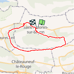

Length
15.5 km

Max alt
529 m

Uphill gradient
371 m
Km-Effort
20 km

Min alt
314 m

Downhill gradient
372 m
Boucle
Yes
Creation date :
2018-04-17 13:46:53.363
Updated on :
2018-04-17 13:46:53.363
5h45
Difficulty : Easy

FREE GPS app for hiking
 SityTrail
IGN / Geographical institutes
SityTrail Plus
The world is yours!
About
Trail Walking of 15.5 km to be discovered at Provence-Alpes-Côte d'Azur, Bouches-du-Rhône, Saint-Antonin-sur-Bayon. This trail is proposed by bernir.
Positioning
Country:
France
Region :
Provence-Alpes-Côte d'Azur
Department/Province :
Bouches-du-Rhône
Municipality :
Saint-Antonin-sur-Bayon
Location:
Unknown
Start:(Dec)
Start:(UTM)
708946 ; 4821709 (31T) N.
Comments