


2017 12 Stroberg Wintzfelden

staubalex
User
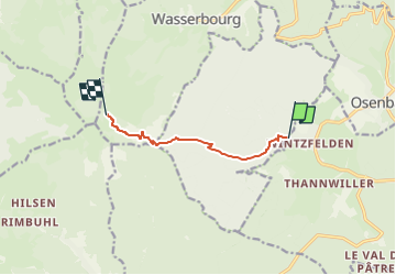

Length
5.7 km

Max alt
1084 m

Uphill gradient
708 m
Km-Effort
12.9 km

Min alt
412 m

Downhill gradient
44 m
Boucle
No
Creation date :
2018-04-17 14:49:59.379
Updated on :
2018-04-17 14:49:59.379
54m
Difficulty : Difficult

FREE GPS app for hiking
 SityTrail
IGN / Geographical institutes
SityTrail Plus
The world is yours!
About
Trail Other activity of 5.7 km to be discovered at Grand Est, Haut-Rhin, Soultzmatt. This trail is proposed by staubalex.
Positioning
Country:
France
Region :
Grand Est
Department/Province :
Haut-Rhin
Municipality :
Soultzmatt
Location:
Unknown
Start:(Dec)
Start:(UTM)
364855 ; 5315442 (32T) N.
Comments