


autre balade digestives

mapomme
User
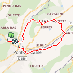

Length
7.4 km

Max alt
182 m

Uphill gradient
158 m
Km-Effort
9.6 km

Min alt
64 m

Downhill gradient
167 m
Boucle
No
Creation date :
2018-04-17 15:12:45.229
Updated on :
2018-04-17 15:12:45.229
1h08
Difficulty : Very easy

FREE GPS app for hiking
 SityTrail
IGN / Geographical institutes
SityTrail Plus
The world is yours!
About
Trail Mountain bike of 7.4 km to be discovered at New Aquitaine, Lot-et-Garonne, Pont-du-Casse. This trail is proposed by mapomme.
Description
Pour transpirer 45 mn avant de remanger. Attention: erreur gps au début, il faut tourner à gauche en face l'école pour commencer la boucle (juste après le petit pont)
Positioning
Country:
France
Region :
New Aquitaine
Department/Province :
Lot-et-Garonne
Municipality :
Pont-du-Casse
Location:
Unknown
Start:(Dec)
Start:(UTM)
313932 ; 4900866 (31T) N.
Comments