


ger RS

LouisROGER
User GUIDE
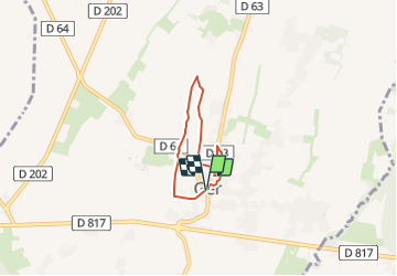

Length
4.5 km

Max alt
408 m

Uphill gradient
28 m
Km-Effort
4.9 km

Min alt
390 m

Downhill gradient
30 m
Boucle
Yes
Creation date :
2018-04-17 15:45:07.499
Updated on :
2018-04-17 15:45:07.499
1h05
Difficulty : Unknown

FREE GPS app for hiking
 SityTrail
IGN / Geographical institutes
SityTrail Plus
The world is yours!
About
Trail Walking of 4.5 km to be discovered at New Aquitaine, Pyrénées-Atlantiques, Ger. This trail is proposed by LouisROGER.
Positioning
Country:
France
Region :
New Aquitaine
Department/Province :
Pyrénées-Atlantiques
Municipality :
Ger
Location:
Unknown
Start:(Dec)
Start:(UTM)
739253 ; 4793058 (30T) N.
Comments