Trail Walking Cherves-Châtelars - Cherves Chatelard et l'étang du gazon - Photo

Cherves Chatelard et l'étang du gazon

© OpenStreetMap contributors
Length
Length
8.7 km
Max alt
Max alt
243 m
Uphill gradient
Uphill gradient
138 m
Km-Effort
Km-Effort  
10.5 km
Min alt
Min alt
169 m
Downhill gradient
Downhill gradient
139 m
Boucle
Boucle
Yes
Creation date :
2018-04-17 15:55:08.712
Updated on :
2018-04-17 15:55:08.712

(0 Reviews)

Walking
Walking
2h33
Difficulty : Easy

Scan this QR Code to open this trail in the SityTrail application

FREE GPS app for hiking

Logo SityTrail SityTrail

IGN / Geographical institutes

Download SityTrail from the App Store Download SityTrail from Google Play

Logo SityTrail SityTrail World

The world is yours!

Download SityTrail from the App Store Download SityTrail from Google Play Download SityTrail on Huawei AppGallery

About

Trail Walking of 8.7 km to be discovered at New Aquitaine, Charente, Cherves-Châtelars. This trail is proposed by alainjoseph6.

Description

Au départ du terrain de foot , à côté du ruisseau La Croutelle, une balade agréable avec la découverte de l'étang du gazon

Elevation profile

Photos

Positioning

Country:
France
Region :
New Aquitaine
Department/Province :
Charente
Municipality :
Cherves-Châtelars
Location:
Unknown
Start:(UTM)
309557 ; 5076240 (31T) N.

Trails nearby

Trail Walking Terres-de-Haute-Charente - La balade de GENOUILLAC - Photo
Walking
alainjoseph6

Walking

Very easy
Terres-de-Haute-Charente, New Aquitaine, Charente, France
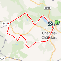
7.3 km | 9.1 km-effort
2h 7min
Yes
Trail Walking Cherves-Châtelars - les Chatelars en Charente - Photo
Walking
rougilabuse

Walking

Medium
Cherves-Châtelars, New Aquitaine, Charente, France
17.5 km | 21 km-effort
4h 38min
Yes


Close
My subscriptions