


M66 - Millas força réal col del Bou - Montner

jeff66
User
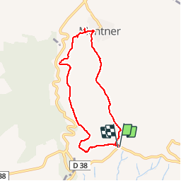

Length
7.4 km

Max alt
322 m

Uphill gradient
228 m
Km-Effort
10.4 km

Min alt
122 m

Downhill gradient
228 m
Boucle
Yes
Creation date :
2018-04-17 16:06:17.762
Updated on :
2018-04-17 16:06:17.762
1h35
Difficulty : Medium

FREE GPS app for hiking
 SityTrail
IGN / Geographical institutes
SityTrail Plus
The world is yours!
About
Trail Walking of 7.4 km to be discovered at Occitania, Pyrénées-Orientales, Millas. This trail is proposed by jeff66.
Description
M66 - Millas força réal col del Bou - Montner - le 12.01.2018
Positioning
Country:
France
Region :
Occitania
Department/Province :
Pyrénées-Orientales
Municipality :
Millas
Location:
Unknown
Start:(Dec)
Start:(UTM)
474042 ; 4730638 (31T) N.
Comments