


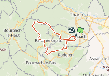
Parking Mairie Leimbach-Roderen-Spannplatz-Abri Hochburg-Abri Baumann-Col du Teufelsgrund-Muhlberg et retour

patrickbeyrath
User

Length
12.4 km

Max alt
757 m

Uphill gradient
501 m
Km-Effort
19.1 km

Min alt
357 m

Downhill gradient
501 m
Boucle
Yes
Creation date :
2018-10-13 05:51:53.959
Updated on :
2018-10-13 05:51:53.971
3h59
Difficulty : Medium

FREE GPS app for hiking
 SityTrail
IGN / Geographical institutes
SityTrail Plus
The world is yours!
About
Trail Walking of 12.4 km to be discovered at Grand Est, Haut-Rhin, Leimbach. This trail is proposed by patrickbeyrath.
Positioning
Country:
France
Region :
Grand Est
Department/Province :
Haut-Rhin
Municipality :
Leimbach
Location:
Unknown
Start:(Dec)
Start:(UTM)
357831 ; 5295058 (32T) N.
Comments