


Arles Col de Paracols

patbt
User
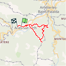

Length
14 km

Max alt
904 m

Uphill gradient
792 m
Km-Effort
25 km

Min alt
266 m

Downhill gradient
783 m
Boucle
No
Creation date :
2018-04-17 17:45:36.06
Updated on :
2018-04-17 17:45:36.06
6h47
Difficulty : Medium

FREE GPS app for hiking
 SityTrail
IGN / Geographical institutes
SityTrail Plus
The world is yours!
About
Trail Walking of 14 km to be discovered at Occitania, Pyrénées-Orientales, Arles-sur-Tech. This trail is proposed by patbt.
Positioning
Country:
France
Region :
Occitania
Department/Province :
Pyrénées-Orientales
Municipality :
Arles-sur-Tech
Location:
Unknown
Start:(Dec)
Start:(UTM)
469480 ; 4700630 (31T) N.
Comments