


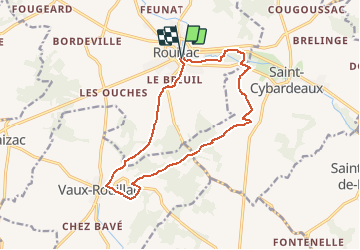
Rouillac les Villars

LaurentBernard
User

Length
14.2 km

Max alt
164 m

Uphill gradient
170 m
Km-Effort
16.5 km

Min alt
90 m

Downhill gradient
173 m
Boucle
Yes
Creation date :
2018-04-17 17:53:17.611
Updated on :
2018-04-17 17:53:17.611
3h35
Difficulty : Medium

FREE GPS app for hiking
 SityTrail
IGN / Geographical institutes
SityTrail Plus
The world is yours!
About
Trail Walking of 14.2 km to be discovered at New Aquitaine, Charente, Rouillac. This trail is proposed by LaurentBernard.
Positioning
Country:
France
Region :
New Aquitaine
Department/Province :
Charente
Municipality :
Rouillac
Location:
Rouillac
Start:(Dec)
Start:(UTM)
728411 ; 5073175 (30T) N.
Comments