


Rando par Hubi. Metzeral 40-06-2015

LUTZMarc
User
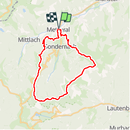

Length
27 km

Max alt
1320 m

Uphill gradient
1168 m
Km-Effort
42 km

Min alt
477 m

Downhill gradient
1167 m
Boucle
Yes
Creation date :
2018-04-17 18:04:41.111
Updated on :
2018-04-17 18:04:41.111
5h25
Difficulty : Unknown

FREE GPS app for hiking
 SityTrail
IGN / Geographical institutes
SityTrail Plus
The world is yours!
About
Trail Walking of 27 km to be discovered at Grand Est, Haut-Rhin, Metzeral. This trail is proposed by LUTZMarc.
Description
impro
Positioning
Country:
France
Region :
Grand Est
Department/Province :
Haut-Rhin
Municipality :
Metzeral
Location:
Unknown
Start:(Dec)
Start:(UTM)
356264 ; 5319599 (32U) N.
Comments