


St Simeux PM

LaurentBernard
User

Length
11.1 km

Max alt
97 m

Uphill gradient
124 m
Km-Effort
12.7 km

Min alt
21 m

Downhill gradient
125 m
Boucle
Yes
Creation date :
2018-04-17 18:24:25.383
Updated on :
2018-04-17 18:24:25.383
2h48
Difficulty : Medium

FREE GPS app for hiking
 SityTrail
IGN / Geographical institutes
SityTrail Plus
The world is yours!
About
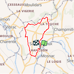
Trail Walking of 11.1 km to be discovered at New Aquitaine, Charente, Mosnac-Saint-Simeux. This trail is proposed by LaurentBernard.
Positioning
Country:
France
Region :
New Aquitaine
Department/Province :
Charente
Municipality :
Mosnac-Saint-Simeux
Location:
Saint-Simeux
Start:(Dec)
Start:(UTM)
731708 ; 5056584 (30T) N.
Comments