Trail Walking Sainte-Austreberthe - Ste Austreberthe Pavilly A-R - Photo

Ste Austreberthe Pavilly A-R

© OpenStreetMap contributors
Length
Length
12.5 km
Max alt
Max alt
152 m
Uphill gradient
Uphill gradient
236 m
Km-Effort
Km-Effort  
15.6 km
Min alt
Min alt
55 m
Downhill gradient
Downhill gradient
236 m
Boucle
Boucle
Yes
Creation date :
2018-04-17 19:20:57.901
Updated on :
2018-04-17 19:20:57.901

(0 Reviews)

Walking
Walking
3h07
Difficulty : Difficult

Scan this QR Code to open this trail in the SityTrail application

FREE GPS app for hiking

Logo SityTrail SityTrail

IGN / Geographical institutes

Download SityTrail from the App Store Download SityTrail from Google Play

Logo SityTrail SityTrail World

The world is yours!

Download SityTrail from the App Store Download SityTrail from Google Play Download SityTrail on Huawei AppGallery

About

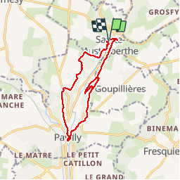
Trail Walking of 12.5 km to be discovered at Normandy, Seine-Maritime, Sainte-Austreberthe. This trail is proposed by MichelARRP.

Description

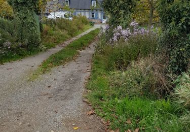
Randonnée à travers bois et quelques petites routes calmes . Chemins gras et boueux.

Elevation profile

Photos

Points of interest

Point of interest Pavilly - Point 1 - Photo
MichelARRP
PAVILLY 

Positioning

Country:
France
Region :
Normandy
Department/Province :
Seine-Maritime
Municipality :
Sainte-Austreberthe
Location:
Unknown
Start:(UTM)
353595 ; 5495932 (31U) N.

Trails nearby

Trail Walking Pavilly - 076-90-Pavilly / St Autreberthe  13.5km - Photo
Walking
rvs147

Walking

Medium
(1)
Pavilly, Normandy, Seine-Maritime, France
12 km | 15 km-effort
3h 23min
Yes
Trail Walking Pavilly - 20220203-Pavilly - Photo
Walking
doudet

Walking

Medium
Pavilly, Normandy, Seine-Maritime, France
12.1 km | 15 km-effort
3h 36min
Yes
Trail Walking Butot - Butot -76- Chemin de randonnée le BOis de Grosfy - Photo
Walking
MichelRando7656

Walking

Difficult
Butot, Normandy, Seine-Maritime, France
14.5 km | 16.7 km-effort
4h 3min
Yes
Trail Walking Pavilly - Pavilly St. Austreberthe (51) - Photo
Walking
randovivi

Walking

Easy
(2)
Pavilly, Normandy, Seine-Maritime, France
10.3 km | 13 km-effort
2h 49min
Yes
Trail Walking Goupillières - Goupillieres 6 - Photo
Walking
francois duparc

Walking

Easy
Goupillières, Normandy, Seine-Maritime, France
6.8 km | 7.6 km-effort
1h 40min
Yes
Trail On foot Hugleville-en-Caux - Le Bois de Grofys - Photo
On foot
PRO

On foot

Easy
Hugleville-en-Caux, Normandy, Seine-Maritime, France
11.6 km | 13.3 km-effort
3h 1min
Yes
Trail On foot Pavilly - 2020-01-22_15h00m10_20200125-pavilly - Photo
On foot
rvs147

On foot

Very easy
Pavilly, Normandy, Seine-Maritime, France
13 km | 16 km-effort
Unknown
Yes
Trail Walking Pavilly - 076-89-Pavilly Ste Austreberthe route du Lin 11km-877-716- - Photo
Walking
rvs147

Walking

Easy
Pavilly, Normandy, Seine-Maritime, France
11 km | 13.7 km-effort
2h 56min
Yes
Trail Walking Limésy - limésy 6 kms - Photo
Walking
nicole.reine@wanadoo.fr

Walking

Medium
Limésy, Normandy, Seine-Maritime, France
6.1 km | 6.7 km-effort
1h 30min
Yes


Close
My subscriptions