


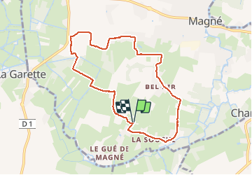
Sainte Macrine 8,3 km

olaze
User

Length
8.3 km

Max alt
39 m

Uphill gradient
81 m
Km-Effort
9.4 km

Min alt
-1 m

Downhill gradient
81 m
Boucle
Yes
Creation date :
2018-04-17 19:32:56.464
Updated on :
2018-04-17 19:32:56.464
1h53
Difficulty : Medium

FREE GPS app for hiking
 SityTrail
IGN / Geographical institutes
SityTrail Plus
The world is yours!
About
Trail Walking of 8.3 km to be discovered at New Aquitaine, Deux-Sèvres, Magné. This trail is proposed by olaze.
Positioning
Country:
France
Region :
New Aquitaine
Department/Province :
Deux-Sèvres
Municipality :
Magné
Location:
Unknown
Start:(Dec)
Start:(UTM)
687869 ; 5130000 (30T) N.
Comments