


Attelage Orbey Boucle Glasborn

Tourisme Equestre Alsace
Promouvoir le Tourisme Equestre en Alsace GUIDE+
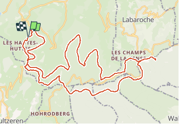

Length
29 km

Max alt
1002 m

Uphill gradient
728 m
Km-Effort
39 km

Min alt
774 m

Downhill gradient
710 m
Boucle
Yes
Creation date :
2018-04-17 21:57:23.955
Updated on :
2021-03-19 13:57:46.351
--
Difficulty : Very easy

FREE GPS app for hiking
 SityTrail
IGN / Geographical institutes
SityTrail Plus
The world is yours!
About
Trail Coupling of 29 km to be discovered at Grand Est, Haut-Rhin, Orbey. This trail is proposed by Tourisme Equestre Alsace.
Photos

Positioning
Country:
France
Region :
Grand Est
Department/Province :
Haut-Rhin
Municipality :
Orbey
Location:
Unknown
Start:(Dec)
Start:(UTM)
359940 ; 5329303 (32U) N.
Comments