Trail Walking Delincourt - Delincourt / Trie-château 11,9 km - Photo

Delincourt / Trie-château 11,9 km

© OpenStreetMap contributors
Length
Length
11.9 km
Max alt
Max alt
151 m
Uphill gradient
Uphill gradient
206 m
Km-Effort
Km-Effort  
14.6 km
Min alt
Min alt
63 m
Downhill gradient
Downhill gradient
206 m
Boucle
Boucle
Yes
Creation date :
2018-04-17 22:50:04.478
Updated on :
2018-04-17 22:50:04.478

(0 Reviews)

Walking
Walking
3h11
Difficulty : Medium

Scan this QR Code to open this trail in the SityTrail application

FREE GPS app for hiking

Logo SityTrail SityTrail

IGN / Geographical institutes

Download SityTrail from the App Store Download SityTrail from Google Play

Logo SityTrail SityTrail World

The world is yours!

Download SityTrail from the App Store Download SityTrail from Google Play Download SityTrail on Huawei AppGallery

About

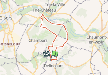
Trail Walking of 11.9 km to be discovered at Hauts-de-France, Oise, Delincourt. This trail is proposed by Marie-Claire-mcp.

Description

Départ Mairie de Delincourt, puis remonter direction Chambors et au calvaire à gauche arrivé au bois des bouleaux à droite puis à gauche jusqu'au réservoir de Trie château et descendre vers la gare puis remonter le long de la voie ferrée jusqu'au golf puis à droite prendre la grande remontée et aller vers Le Mesnil puis la mairie de delincourt.

Elevation profile

Positioning

Country:
France
Region :
Hauts-de-France
Department/Province :
Oise
Municipality :
Delincourt
Location:
Unknown
Start:(UTM)
414827 ; 5455555 (31U) N.

Trails nearby

Trail Walking Delincourt - Delincourt, Le Mesnil, Reilly, La vierge, Delincourt - Photo
Walking
Marie-Claire-mcp

Walking

Medium
(1)
Delincourt, Hauts-de-France, Oise, France
8.7 km | 10.4 km-effort
2h 16min
Yes
Trail Walking Chambors - CHAMBORS - Lattainville-Delincourt-Reillly - Photo
Walking
marcel.F

Walking

Very easy
(1)
Chambors, Hauts-de-France, Oise, France
12.3 km | 15.2 km-effort
2h 54min
Yes
Trail Nordic walking Chambors - Marche Nordique 61 Chambors - Photo
Nordic walking
marcel.F

Nordic walking

Easy
(1)
Chambors, Hauts-de-France, Oise, France
8.4 km | 10.3 km-effort
1h 30min
Yes
Trail Walking Trie-Château - Trie Château - La vallée de l'Aunette - Photo
Walking
marcel.F

Walking

Difficult
(1)
Trie-Château, Hauts-de-France, Oise, France
11.8 km | 13.7 km-effort
3h 0min
Yes
Trail Walking Montjavoult - Montjavoult - Vaudancourt - Photo
Walking
marcel.F

Walking

Easy
(1)
Montjavoult, Hauts-de-France, Oise, France
10.2 km | 12.2 km-effort
2h 39min
Yes
Trail Walking Chambors - Chambors - le dolmen 12 - Photo
Walking
marcel.F

Walking

Easy
(1)
Chambors, Hauts-de-France, Oise, France
12.4 km | 16 km-effort
3h 31min
Yes
Trail Walking Chambors - Chambors - le dolmen 9 - Photo
Walking
marcel.F

Walking

Easy
(4)
Chambors, Hauts-de-France, Oise, France
9.3 km | 12.1 km-effort
2h 38min
Yes
Trail Walking Gisors - gisors champêtre et historique  - Photo
Walking
serge.guerroult

Walking

Difficult
Gisors, Normandy, Eure, France
12.1 km | 13.6 km-effort
2h 13min
Yes
Trail Walking Montjavoult - Montjavoult le gibet Valécourt - Photo
Walking
serge.guerroult

Walking

Difficult
Montjavoult, Hauts-de-France, Oise, France
12.8 km | 15.4 km-effort
2h 19min
Yes


Close
My subscriptions