Trail Walking Saint-Arnoult - St Arnoult - 20180412 - PT - V2 - Photo

St Arnoult - 20180412 - PT - V2

© OpenStreetMap contributors
Length
Length
7.4 km
Max alt
Max alt
142 m
Uphill gradient
Uphill gradient
164 m
Km-Effort
Km-Effort  
9.6 km
Min alt
Min alt
9 m
Downhill gradient
Downhill gradient
163 m
Boucle
Boucle
Yes
Creation date :
2018-04-17 23:19:28.674
Updated on :
2018-04-17 23:19:28.674

(0 Reviews)

Walking
Walking
2h12
Difficulty : Medium

Scan this QR Code to open this trail in the SityTrail application

FREE GPS app for hiking

Logo SityTrail SityTrail

IGN / Geographical institutes

Download SityTrail from the App Store Download SityTrail from Google Play

Logo SityTrail SityTrail World

The world is yours!

Download SityTrail from the App Store Download SityTrail from Google Play Download SityTrail on Huawei AppGallery

About

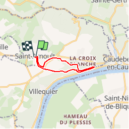
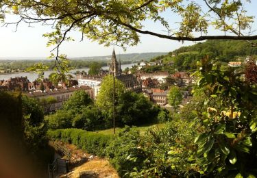
Trail Walking of 7.4 km to be discovered at Normandy, Seine-Maritime, Saint-Arnoult. This trail is proposed by philippe76.

Description

Départ à St Arnoult, place principale. prendre la rte du Havre. AD Cemin Rouleau. AG D281; AD Chemin de Barre Y Va et TD jusqu'à la Pierre Tournante. TD vers La Barre Y va. Demi-tour à la Barre-Y VA; visiter la chapelle Barre-Y-Va, AG avec le GR2; TD à La Guerche, Che Rouleau, AG Rte du Havre au PKG.

Elevation profile

Positioning

Country:
France
Region :
Normandy
Department/Province :
Seine-Maritime
Municipality :
Saint-Arnoult
Location:
Unknown
Start:(UTM)
331225 ; 5488780 (31U) N.

Trails nearby

Trail Walking Rives-en-Seine - Balade à Villequier - Photo
Walking
tracegps

Walking

Easy
(1)
Rives-en-Seine, Normandy, Seine-Maritime, France
9.7 km | 12.5 km-effort
2h 0min
Yes
Trail Walking Rives-en-Seine - 20220421-Caudebec en Caux Journée - Photo
Walking
doudet

Walking

Medium
Rives-en-Seine, Normandy, Seine-Maritime, France
21 km | 27 km-effort
6h 34min
Yes
Trail Walking Arelaune-en-Seine - Saint-Nicolas de Bliquetuit (Vers l'Armada) - Photo
Walking
MichelRando7656

Walking

Very easy
Arelaune-en-Seine, Normandy, Seine-Maritime, France
11.2 km | 12.2 km-effort
2h 32min
Yes
Trail Equestrian Port-Jérôme-sur-Seine - Autour de Triquerville à Cheval - Photo
Equestrian
tracegps

Equestrian

Medium
Port-Jérôme-sur-Seine, Normandy, Seine-Maritime, France
16.6 km | 20 km-effort
2h 30min
Yes
Trail Mountain bike Port-Jérôme-sur-Seine - Autour de Triquerville à Cheval - Photo
Mountain bike
tracegps

Mountain bike

Medium
Port-Jérôme-sur-Seine, Normandy, Seine-Maritime, France
16.6 km | 20 km-effort
1h 30min
Yes
Trail Mountain bike Vatteville-la-Rue - Randonnée en forêt de Brotonne - Photo
Mountain bike
tracegps

Mountain bike

Difficult
Vatteville-la-Rue, Normandy, Seine-Maritime, France
61 km | 73 km-effort
3h 30min
Yes
Trail Walking Rives-en-Seine - les hauts de caudebecq en caux - Photo
Walking
prv

Walking

Easy
Rives-en-Seine, Normandy, Seine-Maritime, France
10 km | 13.3 km-effort
2h 32min
Yes
Trail Walking Saint-Aubin-de-Crétot - St Aubin de Crétot - Photo
Walking
tracegps

Walking

Medium
Saint-Aubin-de-Crétot, Normandy, Seine-Maritime, France
17.8 km | 23 km-effort
3h 40min
No
Trail Walking Rives-en-Seine - Caudebec en Caux - Photo
Walking
tracegps

Walking

Medium
Rives-en-Seine, Normandy, Seine-Maritime, France
20 km | 26 km-effort
4h 0min
Yes


Close
My subscriptions