Mittlach, Lac d'Altenweiher, Vallée de la Wormsa

oscar1
User
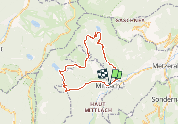

Length
12.7 km

Max alt
1088 m

Uphill gradient
635 m
Km-Effort
21 km

Min alt
524 m

Downhill gradient
636 m
Boucle
Yes
Creation date :
2018-04-17 23:53:14.884
Updated on :
2019-02-09 23:44:15.775
6h00
Difficulty : Unknown

FREE GPS app for hiking
 SityTrail
IGN / Geographical institutes
SityTrail Plus
The world is yours!
About
Trail Walking of 12.7 km to be discovered at Grand Est, Haut-Rhin, Mittlach. This trail is proposed by oscar1.
Description
Randonnée pour bon marcheur.
Positioning
Country:
France
Region :
Grand Est
Department/Province :
Haut-Rhin
Municipality :
Mittlach
Location:
Unknown
Start:(Dec)
Start:(UTM)
353277 ; 5318634 (32U) N.
Comments