


guionnet

cagna
User

Length
3.6 km

Max alt
79 m

Uphill gradient
49 m
Km-Effort
4.3 km

Min alt
36 m

Downhill gradient
56 m
Boucle
No
Creation date :
2014-12-10 00:00:00.0
Updated on :
2014-12-10 00:00:00.0
--
Difficulty : Unknown

FREE GPS app for hiking
 SityTrail
IGN / Geographical institutes
SityTrail Plus
The world is yours!
About
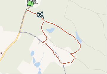
Trail Walking of 3.6 km to be discovered at New Aquitaine, Gironde, Lagorce. This trail is proposed by cagna.
Positioning
Country:
France
Region :
New Aquitaine
Department/Province :
Gironde
Municipality :
Lagorce
Location:
Unknown
Start:(Dec)
Start:(UTM)
726625 ; 4998257 (30T) N.
Comments