Trail Walking Vallon - Vallon 14.04.2018 - Photo
© OpenStreetMap contributors
Length
Length
8.3 km
Max alt
Max alt
494 m
Uphill gradient
Uphill gradient
82 m
Km-Effort
Km-Effort  
9.4 km
Min alt
Min alt
435 m
Downhill gradient
Downhill gradient
86 m
Boucle
Boucle
Yes
Creation date :
2018-04-18 00:32:58.352
Updated on :
2018-04-18 00:32:58.352

(0 Reviews)

Walking
Walking
2h04
Difficulty : Easy

Scan this QR Code to open this trail in the SityTrail application

FREE GPS app for hiking

Logo SityTrail SityTrail

IGN / Geographical institutes

Download SityTrail from the App Store Download SityTrail from Google Play

Logo SityTrail SityTrail World

The world is yours!

Download SityTrail from the App Store Download SityTrail from Google Play Download SityTrail on Huawei AppGallery

About

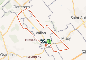
Trail Walking of 8.3 km to be discovered at Fribourg, District de la Broye, Vallon. This trail is proposed by rene.esseiva.

Description

Centre de renfort - contournement de Payerne-Grandcour-Resudens-Carignan 26 km 30 minutes Fr. 5.00
Verrée Auberge de la Couronne route de Bitternaz 16 1562 Corcelles-près-Payerne 026 677 11 03

Elevation profile

Positioning

Country:
Switzerland
Region :
Fribourg
Department/Province :
District de la Broye
Municipality :
Vallon
Location:
Unknown
Start:(UTM)
344191 ; 5193375 (32T) N.

Trails nearby

Trail Walking Gletterens - gletterens - Photo
Walking
Charles Bolzli

Walking

Very easy
Gletterens, Fribourg, District de la Broye, Switzerland
4.1 km | 4.4 km-effort
1h 9min
Yes
Trail Walking Vallon - Carignan - Missy - Photo
Walking
gpiller

Walking

Very easy
Vallon, Fribourg, District de la Broye, Switzerland
10.7 km | 12.2 km-effort
2h 40min
Yes
Trail Car Gletterens - trajet - Photo
Car
Charles Bolzli

Car

Very easy
Gletterens, Fribourg, District de la Broye, Switzerland
13.4 km | 15.3 km-effort
16min
No


Close
My subscriptions