


st Laurent des combes 17 avril 2018

bert16
User
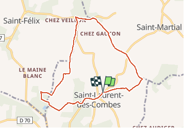

Length
8.7 km

Max alt
178 m

Uphill gradient
177 m
Km-Effort
11.1 km

Min alt
92 m

Downhill gradient
175 m
Boucle
Yes
Creation date :
2018-04-18 00:51:36.824
Updated on :
2018-04-18 00:51:36.824
2h23
Difficulty : Easy

FREE GPS app for hiking
 SityTrail
IGN / Geographical institutes
SityTrail Plus
The world is yours!
About
Trail Walking of 8.7 km to be discovered at New Aquitaine, Charente, Saint-Laurent-des-Combes. This trail is proposed by bert16.
Description
Association des anciens élèves et amis de Brie-sous-chalais 16210. 15 randonneurs.
Positioning
Country:
France
Region :
New Aquitaine
Department/Province :
Charente
Municipality :
Saint-Laurent-des-Combes
Location:
Unknown
Start:(Dec)
Start:(UTM)
267964 ; 5026843 (31T) N.
Comments