Trail Walking Stavelot - WATER TREK - le Parcours des Vallées - 5. AMERMONT -  COO - Photo

WATER TREK - le Parcours des Vallées - 5. AMERMONT - COO

 aqualis
aqualis

User

© OpenStreetMap contributors
Length
Length
16.8 km
Max alt
Max alt
509 m
Uphill gradient
Uphill gradient
524 m
Km-Effort
Km-Effort  
24 km
Min alt
Min alt
233 m
Downhill gradient
Downhill gradient
597 m
Boucle
Boucle
No
Creation date :
2019-06-13 12:17:52.722
Updated on :
2019-06-13 12:17:53.161

(0 Reviews)

Walking
Walking
5h02
Difficulty : Medium

Scan this QR Code to open this trail in the SityTrail application

FREE GPS app for hiking

Logo SityTrail SityTrail

IGN / Geographical institutes

Download SityTrail from the App Store Download SityTrail from Google Play

Logo SityTrail SityTrail World

The world is yours!

Download SityTrail from the App Store Download SityTrail from Google Play Download SityTrail on Huawei AppGallery

About

Trail Walking of 16.8 km to be discovered at Wallonia, Liège, Stavelot. This trail is proposed by aqualis.

Description

Après quelques centaines de mètres de RAVeL, descente sur le coeur de STavelot avant de reprendre le chemin des forêts et la descente vers les lacs et la cascade de Coo.

Elevation profile

Points of interest

Point of interest Stavelot - km 01 - Photo
aqualis
STAVELOT 
Point of interest Stavelot - km 02 - Photo
aqualis
STAVELOT 
Point of interest Stavelot - km 03 - Photo
aqualis
STAVELOT 
Point of interest Stavelot - km 04 - Photo
aqualis
STAVELOT 
Point of interest Stavelot - km 05 - Photo
aqualis
STAVELOT 
Point of interest Stavelot - km 06 - Photo
aqualis
STAVELOT 
Point of interest Stavelot - camping - Photo
aqualis
STAVELOT 
Point of interest Stavelot - abbaye  - Photo
aqualis
STAVELOT 
Point of interest Stavelot - restauration - Photo
aqualis
STAVELOT 
Point of interest Stavelot - info tourisme - Photo
aqualis
STAVELOT 
Point of interest Stavelot - fouilles archéologiques - Photo
aqualis
Point of interest Stavelot - restauration - Photo
aqualis
STAVELOT 
Point of interest Stavelot - hotels - Photo
aqualis
STAVELOT 
Point of interest Stavelot - coeur historique - Photo
aqualis
Point of interest Stavelot - les étangs - Photo
aqualis
STAVELOT 
Point of interest Stavelot - parc - Photo
aqualis
STAVELOT 
Point of interest Stavelot - km 07 - Photo
aqualis
STAVELOT 
Point of interest Stoumont - km 08 - Photo
aqualis
STOUMONT 
Point of interest Stoumont - km 09 - Photo
aqualis
STOUMONT 
Point of interest Stoumont - km 10 - Photo
aqualis
STOUMONT 
Point of interest Stoumont - km 11 - Photo
aqualis
STOUMONT 
Point of interest Stoumont - km 12 - Photo
aqualis
STOUMONT 
Point of interest Stavelot - km 13 - Photo
aqualis
STAVELOT 
Point of interest Stavelot - km 14 - Photo
aqualis
STAVELOT 
Point of interest Stavelot - km 15 - Photo
aqualis
STAVELOT 
Point of interest Stavelot - km 16 - Photo
aqualis
STAVELOT 
Point of interest Stavelot - arrivée -  camping - Photo
aqualis
Point of interest Stavelot - camping - Photo
aqualis
STAVELOT 
Point of interest Stavelot - restauration - Photo
aqualis
STAVELOT 
Point of interest Stavelot - hotels - Photo
aqualis
STAVELOT 
Point of interest Stavelot - cascade de coo - Photo
aqualis
STAVELOT 
Point of interest Stavelot - plopsacoo - Photo
aqualis
STAVELOT 

Positioning

Country:
Belgium
Region :
Wallonia
Department/Province :
Liège
Municipality :
Stavelot
Location:
Stavelot
Start:(UTM)
709874 ; 5588544 (31U) N.

Trails nearby

Trail Walking Stavelot - 2021-06-30_12h14m27_stavelot_13km_new - Photo
Walking
GUIDE
mumu.larandonneuse

Walking

Medium
(2)
Stavelot, Wallonia, Liège, Belgium
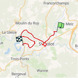
13.4 km | 19.8 km-effort
4h 30min
Yes
Trail Walking Stavelot - 2021-03-10_14h59m08_1227 - Photo
Walking
GUIDE
mumu.larandonneuse

Walking

Difficult
(3)
Stavelot, Wallonia, Liège, Belgium
18.8 km | 26 km-effort
5h 53min
No
Trail Walking Malmedy - RB-LG-09 - Sur les hauteurs dominant la haute vallée de l’Amblève et la Warche - Photo
Walking
PRO

Walking

Medium
(4)
Malmedy, Wallonia, Liège, Belgium
26 km | 34 km-effort
7h 12min
Yes
Trail Walking Stavelot - Francorchamps  - Photo
Walking
motou.bedeur1@gmail.com

Walking

(1)
Stavelot, Wallonia, Liège, Belgium
13.4 km | 18.2 km-effort
3h 56min
Yes
Trail Walking Stavelot - Chemin des Sources |stage 3 STAVELOT - HOCKAI - Photo
Walking
PRO

Walking

Very difficult
(1)
Stavelot, Wallonia, Liège, Belgium
19 km | 25 km-effort
5h 45min
No
Trail On foot Malmedy - Brasserie de Bellevaux - Photo
On foot
PRO

On foot

Easy
(3)
Malmedy, Wallonia, Liège, Belgium
10.2 km | 13.1 km-effort
4h 0min
Yes
Trail Trail Stavelot - Extratrail - Stavelot (red) 23km - Photo
Trail
PRO

Trail

Very difficult
(1)
Stavelot, Wallonia, Liège, Belgium
23 km | 35 km-effort
Unknown
Yes
Trail Trail Stavelot - Extra Trail - Stavelot (blue) 13km - Photo
Trail
PRO

Trail

Difficult
(1)
Stavelot, Wallonia, Liège, Belgium
13.4 km | 19.5 km-effort
Unknown
Yes
Trail Trail Stavelot - Extratrail - Stavelot (green) 9km - Photo
Trail
PRO

Trail

Medium
(1)
Stavelot, Wallonia, Liège, Belgium
10.1 km | 13.9 km-effort
Unknown
Yes


Close
My subscriptions