Trail Walking Unknown - Tampaksiring - Tegalalang Rice Terrace - Ubud - Photo

Tampaksiring - Tegalalang Rice Terrace - Ubud

 lhomme.ph
lhomme.ph

User GUIDE

© OpenStreetMap contributors
Length
Length
22 km
Max alt
Max alt
542 m
Uphill gradient
Uphill gradient
313 m
Km-Effort
Km-Effort  
27 km
Min alt
Min alt
223 m
Downhill gradient
Downhill gradient
612 m
Boucle
Boucle
No
Creation date :
2018-06-26 12:42:43.678
Updated on :
2018-06-26 12:42:43.678

(0 Reviews)

Walking
Walking
5h36
Difficulty : Very difficult

Scan this QR Code to open this trail in the SityTrail application

FREE GPS app for hiking

Logo SityTrail SityTrail

IGN / Geographical institutes

Download SityTrail from the App Store Download SityTrail from Google Play

Logo SityTrail SityTrail World

The world is yours!

Download SityTrail from the App Store Download SityTrail from Google Play Download SityTrail on Huawei AppGallery

About

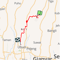
Trail Walking of 22 km to be discovered at Bali. This trail is proposed by lhomme.ph.

Description

Randonnée dans les Rizières

Elevation profile

Positioning

Country:
Indonesia
Region :
Bali
Department/Province :
Unknown
Municipality :
Unknown
Location:
Unknown
Start:(UTM)
313759 ; 9068435 (50L) S.

Trails nearby

Trail Other activity  - Temple rizières Ubud 3 - Photo
Other activity
GUIDE
lhomme.ph

Other activity

Very easy
, Bali, , Indonesia
12.1 km | 13.6 km-effort
5h 27min
No


Close
My subscriptions