Trail Walking Tourville-la-Rivière - Tourville la rivière vers Freneuse et retour - Photo

Tourville la rivière vers Freneuse et retour

© OpenStreetMap contributors
Length
Length
11.9 km
Max alt
Max alt
60 m
Uphill gradient
Uphill gradient
130 m
Km-Effort
Km-Effort  
13.6 km
Min alt
Min alt
1 m
Downhill gradient
Downhill gradient
131 m
Boucle
Boucle
Yes
Creation date :
2019-04-29 10:39:41.137
Updated on :
2019-04-29 10:39:41.2

(0 Reviews)

Walking
Walking
2h41
Difficulty : Medium

Scan this QR Code to open this trail in the SityTrail application

FREE GPS app for hiking

Logo SityTrail SityTrail

IGN / Geographical institutes

Download SityTrail from the App Store Download SityTrail from Google Play

Logo SityTrail SityTrail World

The world is yours!

Download SityTrail from the App Store Download SityTrail from Google Play Download SityTrail on Huawei AppGallery

About

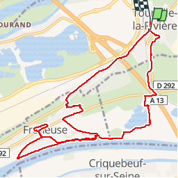
Trail Walking of 11.9 km to be discovered at Normandy, Seine-Maritime, Tourville-la-Rivière. This trail is proposed by MichelRando7656.

Description

Route ; chemins forestiers et chemins de campagne le long de la Seine

Elevation profile

Positioning

Country:
France
Region :
Normandy
Department/Province :
Seine-Maritime
Municipality :
Tourville-la-Rivière
Location:
Unknown
Start:(UTM)
362284 ; 5465696 (31U) N.

Trails nearby

Trail Walking Sotteville-sous-le-Val - Sotteville sous le Val vers Igoville - Photo
Walking
MichelRando7656

Walking

Easy
(1)
Sotteville-sous-le-Val, Normandy, Seine-Maritime, France
8.7 km | 9.3 km-effort
1h 48min
Yes
Trail Walking Oissel - 076-36-Oissel /les Essarts 13km-511-205 - Photo
Walking
rvs147

Walking

Medium
(1)
Oissel, Normandy, Seine-Maritime, France
12.7 km | 15.2 km-effort
3h 19min
No
Trail Walking Oissel - Oissel 13 km  - Photo
Walking
MichelRando7656

Walking

Very easy
(1)
Oissel, Normandy, Seine-Maritime, France
13.3 km | 15.2 km-effort
2h 35min
Yes
Trail Walking Oissel - Oissel 13 km  - Photo
Walking
MichelRando7656

Walking

Very easy
(1)
Oissel, Normandy, Seine-Maritime, France
14.9 km | 16.9 km-effort
2h 35min
Yes
Trail Walking Oissel - Oissel 13 km  - Photo
Walking
MichelRando7656

Walking

Very easy
(1)
Oissel, Normandy, Seine-Maritime, France
13.6 km | 15.4 km-effort
2h 35min
Yes
Trail Walking Pont-de-l'Arche - Pont de l'Arche/ Les Damps (126) - Photo
Walking
randojj

Walking

Medium
(4)
Pont-de-l'Arche, Normandy, Eure, France
11.5 km | 13.9 km-effort
3h 3min
Yes
Trail Walking Les Authieux-sur-le-Port-Saint-Ouen - *les Authieux Igoville 15km - Photo
Walking
rvs147

Walking

Very easy
(1)
Les Authieux-sur-le-Port-Saint-Ouen, Normandy, Seine-Maritime, France
13.9 km | 16.5 km-effort
3h 37min
Yes
Trail Walking Les Authieux-sur-le-Port-Saint-Ouen - 20240305-Gouy - Photo
Walking
doudet

Walking

Medium
Les Authieux-sur-le-Port-Saint-Ouen, Normandy, Seine-Maritime, France
10.7 km | 13.1 km-effort
2h 35min
Yes
Trail Walking Criquebeuf-sur-Seine - 20240220-Criquebeuf  Cool - Photo
Walking
doudet

Walking

Easy
Criquebeuf-sur-Seine, Normandy, Eure, France
9.8 km | 11 km-effort
2h 20min
Yes


Close
My subscriptions