


Attelage Ribeauville Boucle Kaysersberg

Tourisme Equestre Alsace
Promouvoir le Tourisme Equestre en Alsace GUIDE+
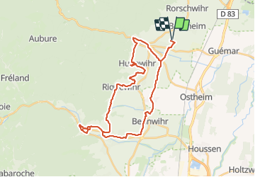

Length
34 km

Max alt
345 m

Uphill gradient
502 m
Km-Effort
41 km

Min alt
202 m

Downhill gradient
502 m
Boucle
Yes
Creation date :
2018-06-26 13:07:39.193
Updated on :
2023-07-10 14:40:15.377
--
Difficulty : Very easy

FREE GPS app for hiking
 SityTrail
IGN / Geographical institutes
SityTrail Plus
The world is yours!
About
Trail Coupling of 34 km to be discovered at Grand Est, Haut-Rhin, Bergheim. This trail is proposed by Tourisme Equestre Alsace.
Photos

Positioning
Country:
France
Region :
Grand Est
Department/Province :
Haut-Rhin
Municipality :
Bergheim
Location:
Unknown
Start:(Dec)
Start:(UTM)
377259 ; 5339407 (32U) N.
Comments